About this project
Infostop is a minimal and fast tool for performing network clustering on spacial data, and in particular it is well suited for detecting stop locations, or points of interest, in GPS data.
Quick example
For unlabeled GPS trace data:
>>> import infostop
>>> import numpy as np
    >>> data
    array([[ 55.75259295,  12.34353885 ],
           [ 55.7525908 ,  12.34353145 ],
           [ 55.7525876 ,  12.3435386  ],
           ...,
           [ 63.40379175,  10.40477095 ],
           [ 63.4037841 ,  10.40480265 ],
           [ 63.403787  ,  10.4047871  ]])
    >>> labels = infostop.label_trace(data)
    >>> np.hstack([data, labels.reshape(-1, 1)])
    array([[ 55.75259295,  12.34353885,   0.        ],
           [ 55.7525908 ,  12.34353145,   0.        ],
           [ 55.7525876 ,  12.3435386 ,  1-.        ],
           ...,
           [ 63.40379175,  10.40477095, 164.        ],
           [ 63.4037841 ,  10.40480265, 164.        ],
           [ 63.403787  ,  10.4047871 , 164.        ]])
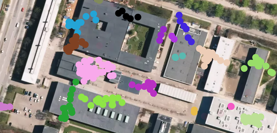
The coordinates can now be plotted onto a map, colored by the assigned labels:
Why should I use Infostop
Pros
- Quick Python based API for finding important places in your GPS data
- Installable with pip, no compiling needed
- No external program needed
- Cross-platform
- More meaningful clustering solutions than DBSCAN (or similar) based methods
Cons
- Not as fast as DBSCAN based methods (although still relatively fast)
- No plotting options yet
Install
pip install infostop
Make sure to read the README.md in the public repository for notes on dependencies and installation.
infostop depends on the following packages which will be
installed by pip during the installation process
numpy>=0.14infomap>=3.0.12
Bug reports & contributing
You can contribute to the public repository and raise issues there.